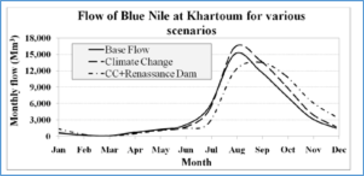
Soil Water Assessment Tool (SWAT)

Purpose: Model hydrologic processes and land use impacts
Developer: USDA, Texas A&M University
Key Features: Model land use change over time; ArcGIS interface; model large basins
Latest Release: 2015, Version 5.1.007
OS Platform: Windows
Cost: Free: Requires ArcGIS and Spatial Analyst Free GIS: QGIS, Mapwindows
Related Software: HEC-HMS, eWater Source, SOBEK
Website: SWAT

Introduction

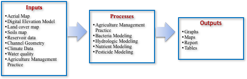
The SWAT (Soil Water Assessment Tool) model, first released in the 1990’s, is a small watershed to river basin-scale model that simulates the quality and quantity of surface and groundwater and predicts the environmental impacts of land use, land management practices, and climate change. The water balance, or the flow of water in and out of a hydrologic system, informs all processes in the SWAT model because of its impact on plant growth, sediment, nutrients, pesticides and pathogens. In order to model hydrologic processes, the SWAT model first divides basin of interest into sub-basins, and then further into hydrologic response units (HRUs) based on land use, management and soils. SWAT estimates runoff for each HRU separately, and then the total runoff for the entire basin. The SWAT model is widely used for hydrologic studies, climate change studies, and water quality studies including nutrient loading, total daily maximum loads, pesticides and bacteria. Key features of the SWAT model include its ability to perform on multiple GIS platforms, including ArcGIS, Mapwindows (MWSWAT), or QGIS (QSWAT). SWAT can also be integrated with the groundwater modeling software MODFLOW.

Advantages and Limitations

Advantages Limitations
  • Software code in public domain and open source
  • Simulates pollutant loading and downstream impacts
  • Free version developed for Mapwindows and QGIS
  • Extensively used around the world with 700 peer review articles
  • Training provided from courses through universities
  • Calibration, uncertainty and sensitivity analysis available through a separate program (SWAT CUP)
  • Models agricultural practices
  • User manual and technical manuals are available
  • Spatial representation of HRUs ignores pollutant routing within a sub-watershed
  • Model formulas are empirical
  • Not applicable for 2D or 3D hydraulics applications
  • Limited snowmelt model
  • Erosion and sediment transport is limited

Illustrative Screens

Sample Applications

Africa East Asia and the Pacific Europe & Central Asia Latin America & the Caribbean Middle East and North Africa South Asia
Entro (Water Balance) Mekong (Hydrologic) Nicaragua (Hydrology, Water Quality)

World Bank - All rights reserved.