Canopy/Plot Reduce/Plot Hound
| Name/Title | Canopy/Plot Reduce/Plot Hound |
| Source | SilviaTerra |
| Category | Analytical Tool (Software) |
| Sector | Forestry |
| Technology Platform | Plot Hound app runs on Android/iOS |
| Date started/Timeframe | January 2010-present |
| Website/URL | https://www.silviaterra.com/ |
| Primary Language(s) | English |
| Location | Cambridge, MA |
| Keywords | Forestry, cruising |
| Targeted Stakeholder | Various; largest clients are timber companies that buy or invest in forested land. |
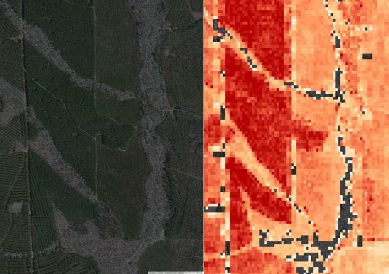
Canopy, Plot Reduce, and Plot Hound are software programs developed and implemented by SilviaTerra, a company that combines biometrics, remote sensing, big data, cloud computing and mobile applications to streamline and accelerate forest inventory work and analysis. The company combines free Landsat satellite imagery, National Agriculture Imagery Program (NAIP) information and Digital Elevation Models (DEMs) with algorithms they have developed to assess timber stands. For forests larger than 10 acres, SilviaTerra can determine the diameters and species of trees in the area with 95% accuracy for trees per acre and basal area. Primary clients include larger timber companies, for whom the software works to assess optimal cutting, planting and fertilizing schedules to maximize profit. Forest inventories are made more efficient with a fine-grained stratification of the forest using less than half of the plots needed for a conventional cruise yielding the same degree of accuracy. Plots are clustered to reduce travel times, further increasing efficiency.
SilviaTerra’s software package works as follows:
- Users first download the free Canopy software (Silviaterra’s cruising workflow and reporting system) (https://www.silviaterra.com/canopy/#gettingstarted-scroll) to design cruises and analyze results.
- Through Canopy, users add stands via a map or upload GIS files, and input their cruise protocol online.
- Users download the Plot Hound app. The cruise defined using canopy is uploaded to the Plot Hound app.
- Plot Hound is used to collect data during the cruise. Results are available in Canopy.
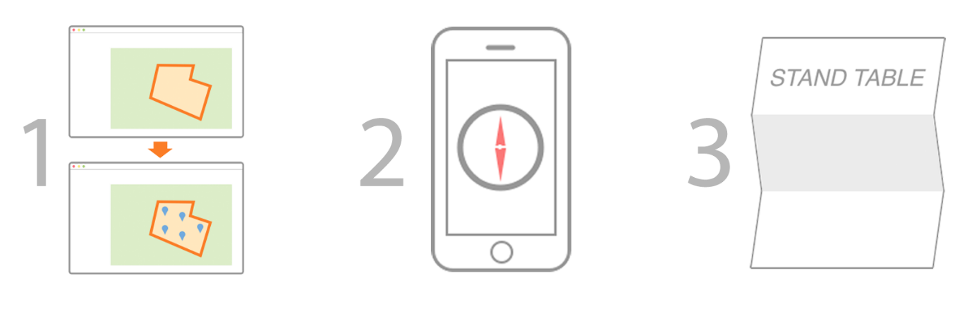
Photo: (1) BEFORE CRUISE: Use the SilviaTerra website to upload tree stand boundary; SilviaTerra analyzes the associated satellite imagery to identify plot sampling locations and upload plot locations to Plot Hound. (2) CRUISING: During the cruising phase, users can use the Plot Hound app to physically locate and manually collect data from each stand; the Plot Hound uploads the data collected to the SilviaTerra website. (3) AFTER CRUISE: SilviaTerra combine cruise data with satellite imagery to create a stand-level inventory with species and diameter for each tree. SilviaTerra can also generate height and volume estimates. The stand-level inventory is the available for download from the company’s website.
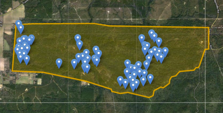
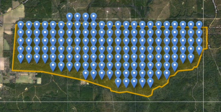
SilviaTerra’s Plot Reduce software significantly reduces the number of forest stands requiring manual data collection. Given forests of roughly the same type, plot data from one Plot Reduce inventory can be used to calibrate an inventory estimate on forests within a 10 mile radius. The example above shows that for a conventional cruise on a 2,446 acre tract (left image), 150 plots would require manual data collection, usually one of the most time-consuming and expensive activities for timber companies. Using Plot Reduce on this same tract, only 61 plots are required for the same level of accuracy, or a 60% reduction in plots.
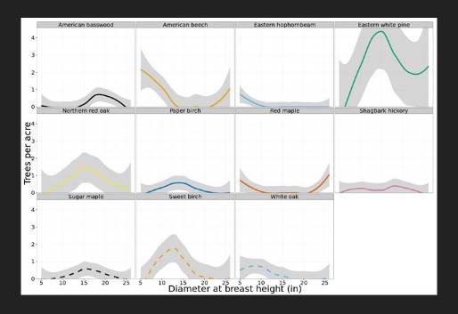
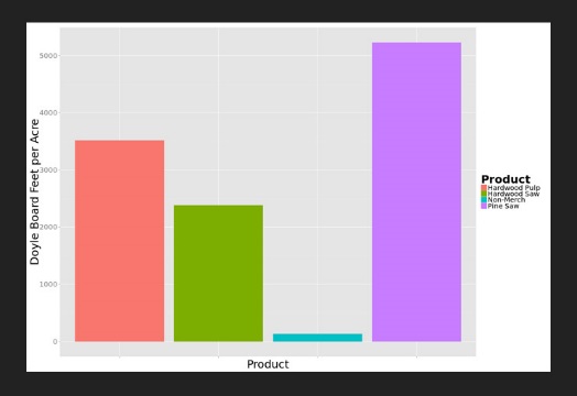
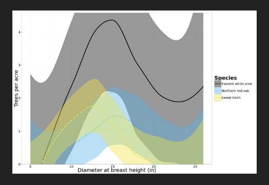
Species diameter distribution; Volume by Product; Stats (trees per acre, basal area, and QMD) provided by SilviaTerra through Canopy.
Screenshot of website
How can the ICT product/innovation benefit the project?
SilviaTerra’s software package could allow for efficient cataloging of Indonesia’s remaining forest base, including areas of invasive species overgrowth and deforestation, and would allow a variety of potential stakeholders to view climate change impacts on the forests.
http://www.technologyreview.com/news/516411/the-app-craze-branches-into-forestry/http://www.bloomberg.com/bw/articles/2012-07-05/zack-parisas-forest-inventory-software
http://www.scientificamerican.com/article/foresters-now-monitoring-tree-populations-from-space-slide-show/
http://landsat.gsfc.nasa.gov/?p=9607
World Bank - All rights reserved.