Drones are small, unmanned aircraft capable of capturing high resolution imagery with high resolution cameras or sensors. They fly at low altitudes, allowing them to fly under heavy cloud cover, usually an obstacle in using remote sensing data. Drones can take off and land vertically and are operated from a laptop on the ground. Their in-built GPS allows them to be preprogrammed to fly certain routes, and to maintain their position in adverse weather conditions. In addition, it allows the drone to georeference images collected. Drones can collect 3D surface images and some offer video glasses that allow the operator to view the live image from the drone camera in real time.
Drones have also been paired with LiDAR (light detection and ranging) technology, which uses light pulses in the way a radar uses sound, to measure distance. This method can create 3D images of forests and forest canopies as well as other landscapes. (See FP Innovations: https://fpinnovations.ca/Pages/index.aspx, one of the largest private scientific R&D centers, which is using this technology to create 3D images of forested lands in Canada)
While drones have many benefits, the largest of which involves increasing the efficiency of mapping and data processing while decreasing survey costs, significant airspace limitations exist.
Potential applications for forestry: Mapping of forested areas; stand delineations (mapping of like forest types for management purposes) – create stand maps that would then be ground-truthed, with drones identifying the most representative and efficient places to sample. This method is similar to the methodology employed by SilvaTerra but using drones instead of remote sensing. Drones could also be used to monitor logging jobs remotely. Drones can measure tree height, canopy density, and data can be used to assess where to build a road, power lines, or other infrastructure, or to assess drainage patterns. Drones may also be helpful in conducting same-day harvesting assessments: http://www.northernontariobusiness.com) Using drones in forestry educational video: https://vimeo.com/116815632 Companies using drones for forestry applications: http://sharpershape.com/
https://novadrone.com/drone-forestry
https://openforests.com/drone-mapper
Use of drones in forestry: sustainable management from the air:
href="http://www.ihb.de/wood/news/Ligna_drones_forestry_39591.html">http://www.ihb.de/wood/news/Ligna_drones_forestry_39591.html
https://www.sensefly.com/home.html
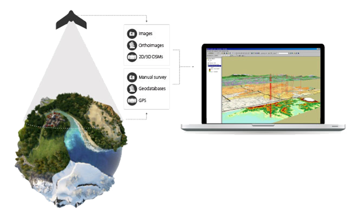
GIS Drone Workflow: from https://www.sensefly.com/applications/gis.html
| Drone acquisition & generation of raster data |
|
| Extraction of vector data |
|
| Import & layering of vector & raster data |
|
| Analysis & decision making |
|
Drone mapping of forests in Ghana:
https://www.wageningenur.nl/en/newsarticle/Drone-mapping-of-forest-ecosystems-in-Ghana.htm
Drone mapping – (http://www.orangutan.com/conservation-drone-project/)
World Bank - All rights reserved.