MODELING SEDIMENT
The study modeled the fate and transport of sediment in the Kaligandaki Basin using two hydrologic models: the SWAT hydrologic model and the InVEST Sediment Delivery Ratio (SDR) model. This page provides an interactive overview of these modeling methodologies; details on the calibration and validation methods used, as well as a more thorough discussion of the methodology employed, are available in the full report here.
The study used the SWAT model to characterize sediment sources within the Kaligandaki Basin, and to model the potential impacts of non-structural land management activities on sedimentation. The study used the InVEST SDR model to model the potential impacts of road construction on sedimentation.
In this study, the SWAT model divided the Kaligandaki watershed into 93 sub-basins. Based on the unique combination of land use, soil and slope, and the selected sub-basin threshold, the 93 sub-basins were further divided into 1,201 HRUs. Baseline results of the SWAT model included rainfall, water yield, sediment yield, and sediment concentration.
Baseline results of the SWAT modeling process are available through the data tool here. Non-structural land management activities to mitigate sediment that were run through the model are described here, and results of the analysis are described here and available to view interactively through the Kaligandaki mapping tool here.
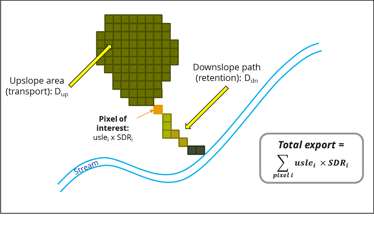
Due to constraints related to gathering the spatial location of future rural road construction and likely impacts of construction practices with and without sediment mitigation, the study conducted a separate analysis for road construction using the InVEST Sediment Delivery Ratio (SDR, version 3.3.0) model. This analysis occurred in parallel to the SWAT hydrologic modeling. The InVEST SDR model is a spatially-explicit hydrologic model developed by The Natural Capital Project (the user guide is available here), designed to evaluate sediment sources and to model the role of land cover and management in mitigating erosion and sediment delivery into streams. The SDR model considers processes affecting sediment dynamics at the catchment scale, such as rainfall intensity, soil properties, topography and vegetation; as well as anthropogenic land use and management factors. The outputs from the SDR model include the total sediment load delivered to the stream at an annual time scale (called sediment export, given in tons), as well as the amount of sediment eroded in the catchment and retained by vegetation.
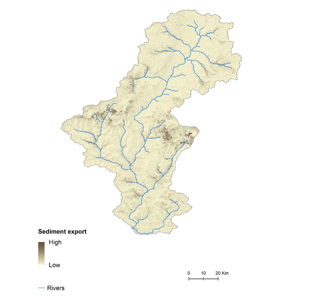 Sediment export results from the InVEST SDR model for the Kaligandaki Basin
MODELING SEDIMENT MITIGATION
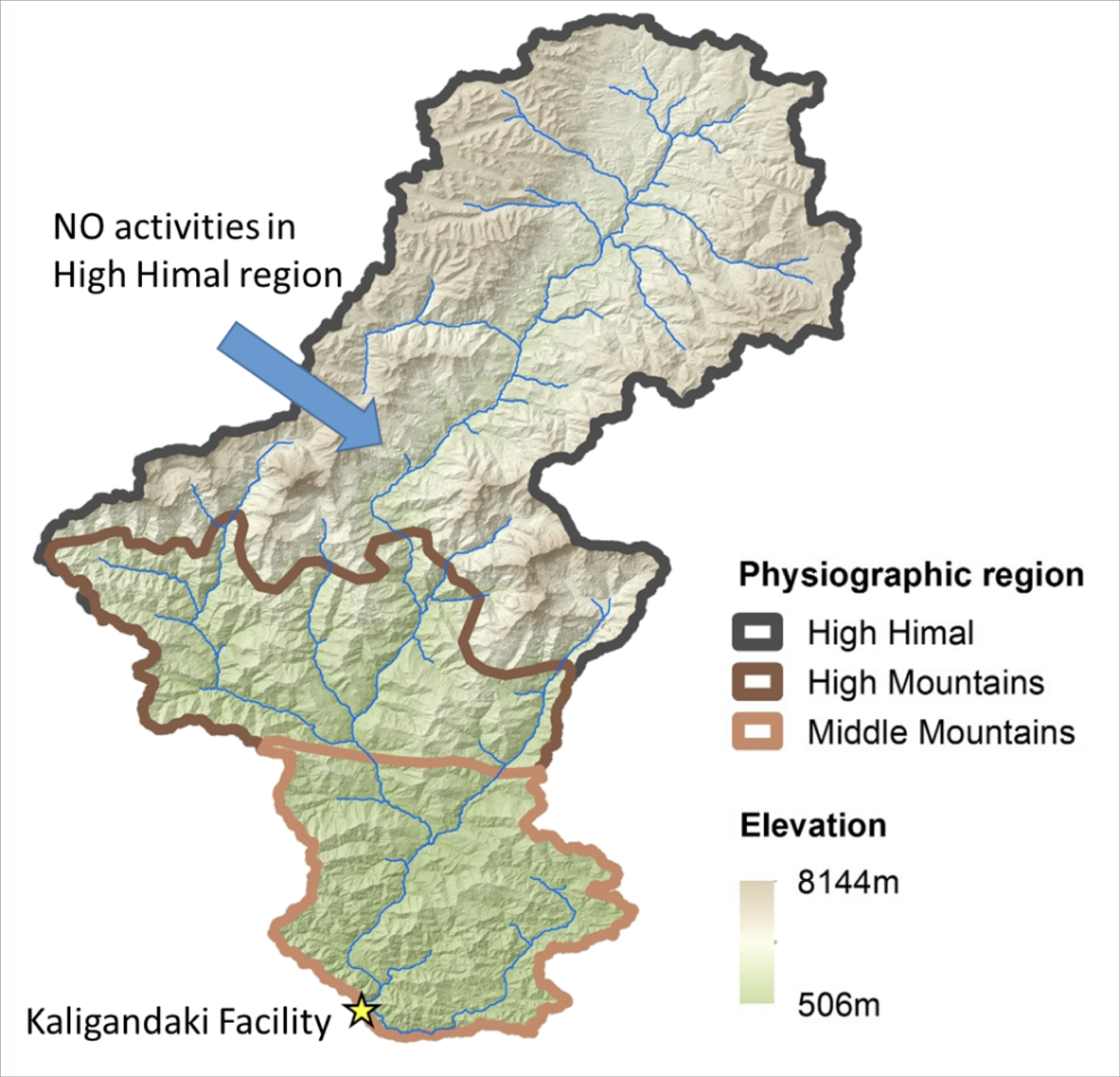
Activities with the potential to mitigate sediment within the Kaligandaki Basin were identified in three categories: non-structural interventions; structural interventions, and road construction mitigation interventions. Due to stakeholder feedback on the difficulty of implementing sediment control activities in the remote High Himal region, the study only considered activities in the Middle and High Mountain physiographic regions; no activities were considered in the High Himal region.
Non-Structural Interventions
The study defined a set of representative catchment management activities in consultation with stakeholders, including Sloping Agricultural Lands Technologies (SALT), conservation farming, reforesting degraded areas, and forest management/conservation. Implementation of these activities was modeled in the calibrated SWAT model for every feasible location in order to estimate their potential impacts and identify activities and locations where catchment management could have the greatest impact. The tiles below provide additional detail and resources for each of the non-structural interventions included.
The study defined a set of representative catchment management activities in consultation with stakeholders, including Sloping Agricultural Lands Technologies (SALT), conservation farming, reforesting degraded areas, and forest management/conservation. Implementation of these activities was modeled in the calibrated SWAT model for every feasible location in order to estimate their potential impacts and identify activities and locations where catchment management could have the greatest impact. The tiles below provide additional detail and resources for each of the non-structural interventions included.
The study modeled three different scenarios for non-structural interventions: 1) “baseline”, using the current (2000) land cover inputs; 2) “full implementation”, applying SALT, conservation farming, and reforestation activities in every HRU where they are possible; and 3) “avoided degradation”, using the same setup as full implementation, but with all possible HRUs currently under non-degraded forests converted to degraded forest.
The difference between the baseline sediment load and the load from scenarios of full activity implementation (based on SWAT results) represents the maximum improvement that can be attained through the modeled catchment management activities. Due to landscape factors such as slope, soils, climate variability, and existing land management, these differences can be greater in some areas than in others, even for the same activities. The study used the difference to rank potential activity areas based on per-hectare improvements in sediment load.
Prioritization According to Budgetary Considerations
The study then assessed impacts of land management activities in the highest ranking areas across three budget scenarios: 1) the NEA’s budget of 0.8M USD, to be spent within the area immediately adjacent to the facility (Harmichaur, Shrikrishna Gandaki, and Nibuwakharka VDCs,; 2) 0.8M USD, to be spent within the overall watershed area; and 3) 10 times the NEA budget (8M USD), to be spent within the overall watershed area. This last scenario represents priority locations where collaborative watershed management could be undertaken in the future, with the goal of reducing overall sediment loads in the basin through broader partnerships and community engagement.
Starting with the top-ranking HRU and going down the list, each HRU was selected, and the associated costs summed, until the target budget was spent. For each budget scenario, the SWAT model was run again to estimate the total change in water yield and sediment resulting from implementation of the budget-constrained scenarios. This was done by altering the input parameters for the priority HRUs, to reflect implementation of the selected activity.
Structural Interventions
Structural interventions include such engineering methods as check dams, settling basins, and channel engineering, and were considered in those areas where the non-structural interventions were unable to significantly impact sediment loads, perhaps due to insufficient area on which to implement the selected activities, natural topographic or soil characteristics, or high connectivity between sediment-generating areas and streams. In such places, structural interventions may be required to manage sediment.The study identified key areas for structural interventions based on sub-basin sediment loads, because engineering structures are not tied to a particular land cover type (and thus HRU), but instead are designed for channels or other areas of concentrated flow which are best represented at the sub-basin level.
Priority areas for structural interventions were identified based on the following criteria: 1) the sub-basin is in the top 30% in terms of its annual sediment load in the baseline scenario (highest loads); 2) the sub-basin exhibits a low change per unit cost when non-structural interventions are fully implemented, relative to other sub-basins (not cost-effective); and 3) the sub-basin shows 10% change in sediment load when non-structural interventions are fully implemented, regardless of their per unit cost (not effective). Sub-basins that met criteria 1 and 2 were designated “medium priority” for structural interventions, meaning that sediment may be managed through non-structural land management activities, but that it is probably not cost-effective to do so. Those sub-basins that met criteria 1 and 3 were designated “high priority” for structural interventions, meaning that non-structural land management activities are unlikely to significantly reduce sediment loads at any cost.
Road Construction Mitigation
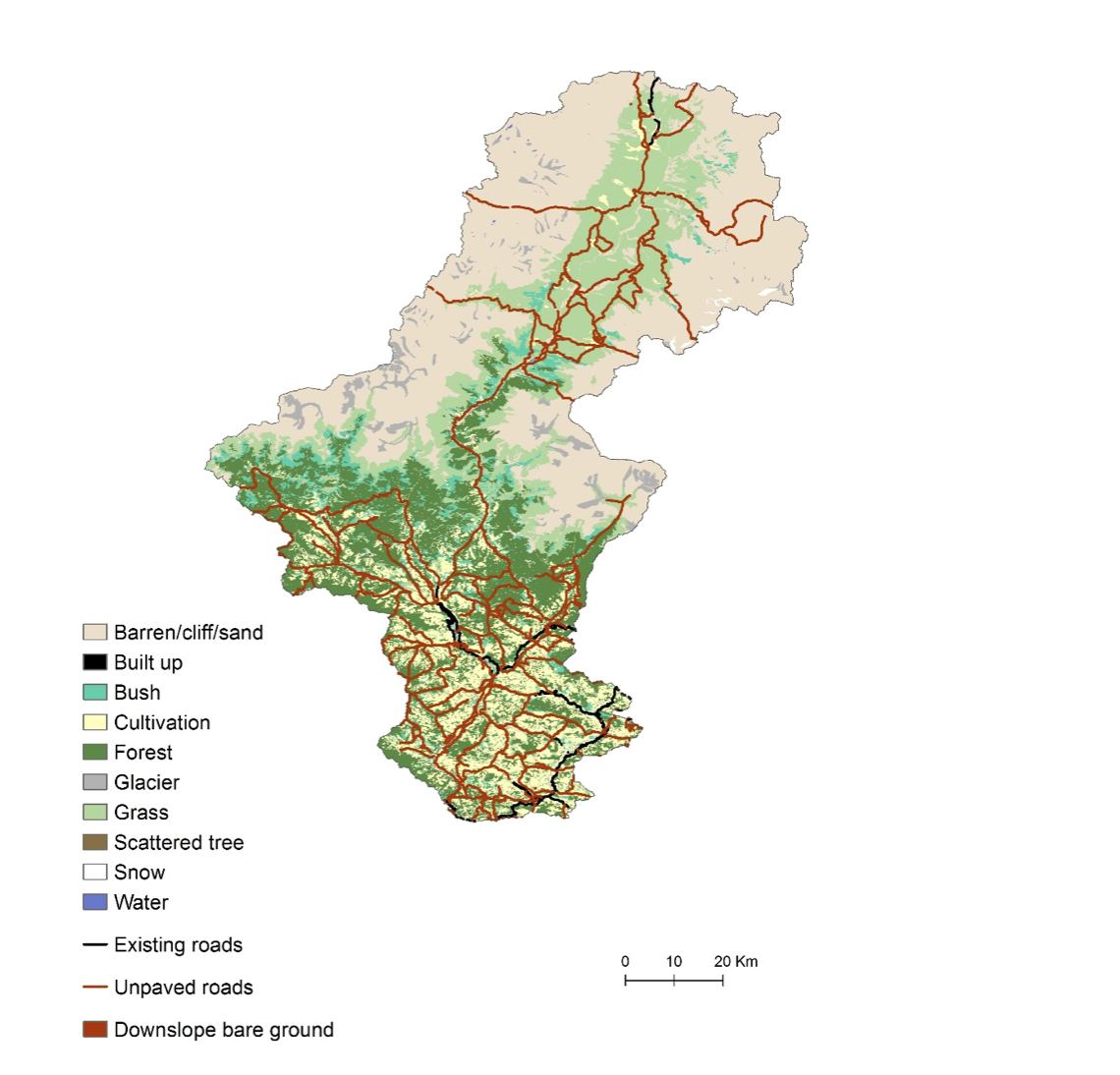
The primary concern with new road construction in the Kaligandaki Basin is the unregulated development of dirt roads in rural areas, which often results in excessive erosion and the loss of vegetation downslope (Pantha et al 2008). Road construction mitigation to reduce sediment was considered in places where new unpaved road construction had the greatest probability of contributing to high sediment loads, in other words where engineering practices are most needed to mitigate potential erosion impacts near construction sites in order to prevent sediment from reaching nearby streams. The SDR model was chosen for this analysis because, unlike SWAT, it allows for a pixel-level analysis of road construction (as opposed to the HRUs required by SWAT), and therefore allowed the study to capture the effects of associated vegetation loss that can happen directly downslope from poorly constructed roads.Three scenarios were developed using the SDR model to assess the potential impacts of rural road construction: a baseline scenario, an unmitigated scenario, and a mitigated scenario. Each scenario resulted in a measure of sediment export, defined as the amount of erosion (tons/year) that is not retained by vegetation on the landscape but instead enters the nearest stream. The different in sediment export between the unmitigated and mitigated scenarios represents the value of proper road engineering and construction for managing sediment loads. The study identified priority areas for mitigation practices where this difference between the unmitigated and mitigated scenarios was greatest; results are available to view using the interactive results tool.
 To model sediment mitigation for roads three scenarios were considered: a
baseline
scenario of existing roads, and mitigated and unmitigated scenarios, where
unpaved roads
were assumed to be converted to paved roads with or without proper sediment
mitigation
techniques.
To model sediment mitigation for roads three scenarios were considered: a
baseline
scenario of existing roads, and mitigated and unmitigated scenarios, where
unpaved roads
were assumed to be converted to paved roads with or without proper sediment
mitigation
techniques.
RESULTS AND RECOMMENDATIONS
Based on the sediment modeling methodology employed, the study developed general recommendations for priority locations where the different types of catchment management activities – non-structural (land management) activities, structural interventions, and improved road construction practices – would allow for a maximum reduction of sediment sources in the basin at the lowest cost.
Results of the modeling analysis are summarized below, and are followed by an interactive tool that allows the user to visualize scenario results and other pertinent elements of the Kaligandaki Basin.
Key takeaways from the modeling exercise are:
- The modeling results suggest that between 50 to 73% of the sediment load in the Kaligandaki basin comes from the High Himal physiographic region, so non-structural or structural interventions to reduce sediment in the lower half of the basin will affect a maximum of 50% of the total sediment load.
- The geologic setting of this region means that high sediment levels are natural, and the focus of catchment management should be on reducing excess anthropogenic sources of sediment, such as road construction, forest degradation, farming in unsuitable areas and without soil conservation measures, etc.
Modeling Results
Kaligandaki Analysis Interactive Results Tool
| Scenario | Description | Budget |
|---|---|---|
| Baseline | Current landscape, no management activities | N/A |
| Full implementation | Current landscape + 4 activities done in all places possible | 111M USD (12B rupees) |
| 0.8 M USD, Restricted (within 3 VDCs only) | Current landscape + activities done only withon 3 VDCs bordering the hydropower facility | 0.8M USD (86M rupees) |
| 0.8 M USD, Unrestricted | Current landscape + activities done in most cost-effective areas in the lower basin | 0.8M USD (86M rupees) |
| 8 M USD, Unrestricted | Current landscape + activities done in most cost-effective areas in the lower basin | 8M USD (860M rupees) |