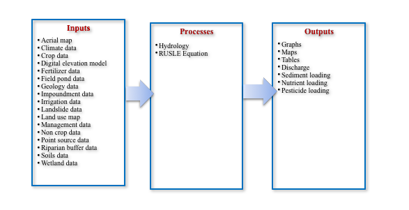
Introduction
The AnnAGNPS pollution model, first released in 1989, is a suite of tools used to evaluate impacts of management
decisions on water, sediment, and chemical loading in a watershed. AnnAGNPS is a distributed model – from a
watershed geometry perspective, it discretize the watershed into a uniform grid. Daily runoff is calculated
using the Soil Conservation Service runoff curve number and the RUSLE Revised Universal Soil Loss Equation
calculates sheet and rill erosion. The RUSLE equation is defined at the cell level where each cell can have its
own parameters, including farm operations. AnnAGNPS can be used to evaluate the long-term impacts of non-point
source pollution from agricultural watersheds and to compare various management practices.
The AnnAGNPS model allows the user to track pollution sources at the grid scale level. The software has tools to
track pollution from the source to the outlet.