Climate
Climate Stations
Rainfall analysis in Africa based on gauge data now excludes the Congo Basin due to a lack of climate stations. As shown in this graphics, there were over 50 climate stations that measured precipitation. In approximately 20-years from 1990-2010, the number of climate station went from 50 to under 10. Today, rainfall is now measured with the use of proxies such as discharge since there is a relationship discharge and rainfall.
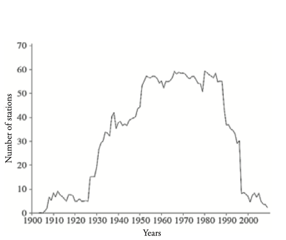
Source: Washington et al (2013)13
Temperature
There are fewer climate stations on temperature than there are available on precipitation. The average mean temperature is approximately 25°C. Peak temperature occurs in March while the low occurs in July. Temperature also decreases from west to east.
Trends: Temperature has increased over the previous decades. For example, there has been a temperature increase of 0.5-1°C during 1980-1990. This temperature increase has also extended to extreme temperature where the hottest day is now 0.25°C higher and cooler weather is now less frequent.
Precipitation
The average annual precipitation is approximately east to west around 1900 mm/year and decreases northward and southward to 1100 mm/year. Annual precipitation in the humid forest is approximately 1500-2000 mm/yr. Forest savannah have a distinct drying season where precipitation ranges from 1200-1600 mm/year. Gabon equatorial rainforest has the highest precipitation that can exceed 3000 mm. In the equatorial forest, precipitation occurs every month while the western regions have a dry season from January to March. At the edge of the rainforest, precipitation is approximately 1200-1600 mm/yr which causes the landscape to change to deciduous forest and eventually woodlands.
Rainfall migrates northwards from the southern point of the basin while the northern end is in a dry season. By April, it would have reached the central part of the basin and reach the northern point in July. In July, when the north end is having its wet season, the southern portion is having a dry season. Rainfall migrates southwards in September and crosses the central area of the basin in November. Between 5 °N - 5°S, rainfall is bimodal, while the Northern and southern end is unimodal.
Trends: On average, precipitation has decreased by 31 mm/decade from 1955-2006. The decreasing trend has not been uniformed spatially or temporally throughout the basin. spatially over the basin. Congo and southern Cameroon saw a decreasing in precipitation to 1990, while Gabon and Central African Republic had an increase in precipitation after 1980 and 1985.
Disasters
The Congo basin is also subject to major floods even though the impacts are not felt in most of the basin given the sparse population distribution in most of the basin.
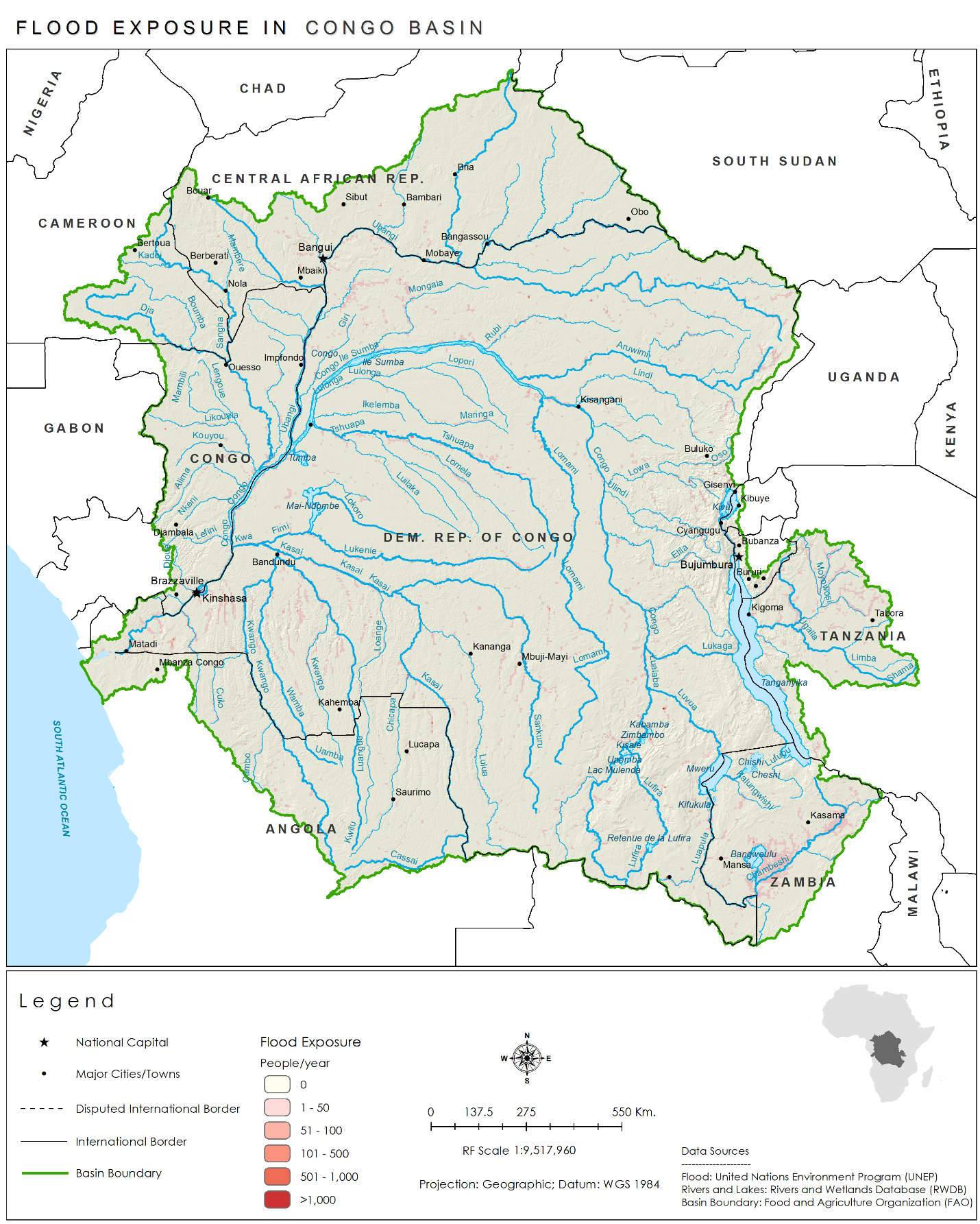
Flooding has occurred on an average annual basis with varying degrees of damages in terms of loss of life, structures, and total number of people affected. The flood observatory map show flooding location from 2013.
Droughts or more specifically longer dry season have becoming more occurring since 1988 where the dry season has been extended by 10 days/decade with some places having a dry season extended by 30/days per decade. Again, the exposure is limited to the densely populated areas near the east.

This video shows drying of the Congo Basin from 2000-2012. Forest fires occur on an annual basis, but it cannot identify between deforestation or cyclical farming performed by small scale farmers.
Climate Change
Climate portal displays the ensemble model for temperature ranges from a median increase of 1 °C for the low Representative Concentration Pathways (RCP) 2.6 emission scenario to over 4.0° C for the RCP 8.5 high emissions scenario. For precipitation, the ensemble model has not yet reached a consensus where some models predict, and increase, and others predict a decrease. It’s impact on global climate is highly complex, but to put simply it affects moisture transport, rainfall patterns and the overall global climate along being a carbon sink.
https://climateknowledgeportal.worldbank.org/watershed/433/climate-data-projections
Climate change may increase runoff in the Congo Basin by 7% on average by 2065, with runoff increases projected in the equatorial region and the northern and southwestern areas of the Congo Basin, but runoff decreases projected in northeast and southeast areas.
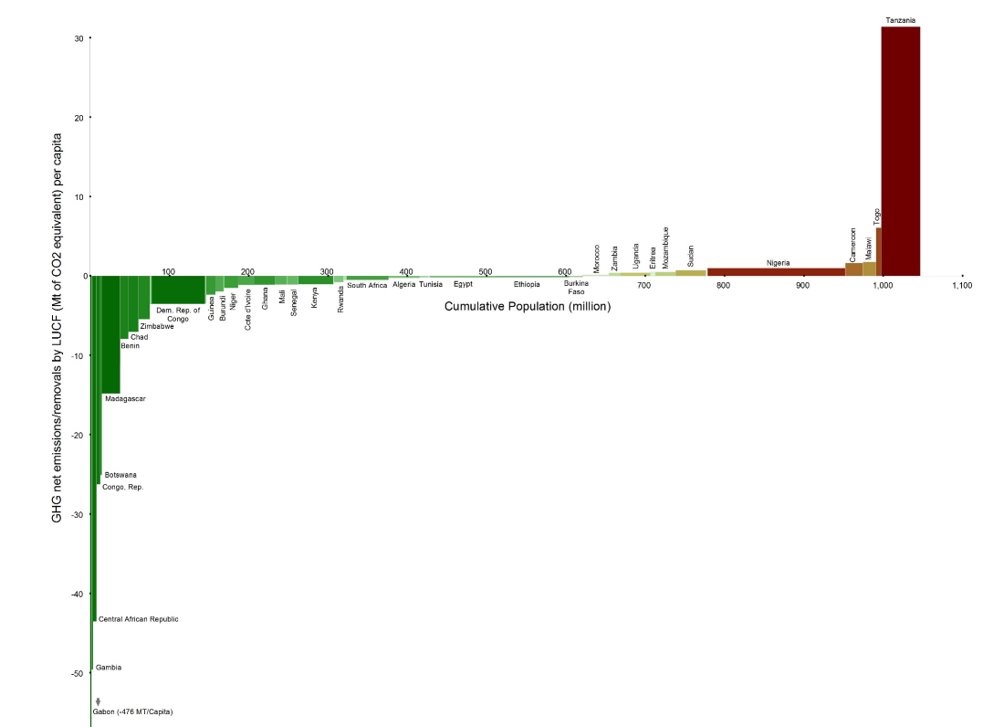
The countries of the basin contribute little to Africa’s continental global greenhouse gases (GHG) contribution (especially from fossil fuels), even as Africa as a whole contributes about 4% of global GHG emissions.
However, many of the countries of the Congo basin have a significant role as Carbon sinks as shown in this figure. The map indicates that the Congo basin acted as a large carbon sink from 2015-16. This region is home to the world’s most extensive tropical peatland, which covers an area larger than the size of England. Research released in 2017 found that the peatland holds the equivalent of 20 years’ worth of fossil fuel emissions from the US.