Overview
Much of the research on the Congo Basin has historically stayed within the narrow confines of traditional forest, climate, and water disciplines. In recent years, however, there has been a move towards interdisciplinary research that explores the intricate nexus between forests, climate, and water. This research is helping to provide a more holistic understanding of these inextricably intertwined aspects of the Congo Basin’s future. One study has issued a call to action to move from a carbon-centric understanding of trees and forests to an understanding of the hydrological and cooling impacts of trees and forests as a “first order of priority”.
Understanding the Nexus: In Congo Basin
To understand the Congo Basin, as any other basin requires an appreciation of the hydrologic cycle. Precipitation over land comes from two primary sources: (1) atmospheric transport of water vapor generated over both oceans and land surfaces external to a locally defined area, and (2) local precipitation recycling, where water vapor is released into the air by terrestrial vegetation in a specific location. Most water evaporated from the oceans (90%) returns to the oceans as rainfall, but 10% is transported to terrestrial surfaces, where it combines with terrestrial evaporation to contribute to rainfall on continents. Historically, hydrology has focused on the interaction between land and water, with less attention given to the role of the atmosphere in the hydrologic cycle. Given the manner in which moisture is transported both horizontally and vertically, however, has significant implications for precipitation and water availability across the Congo Basin, the African continent, and globally, and is therefore
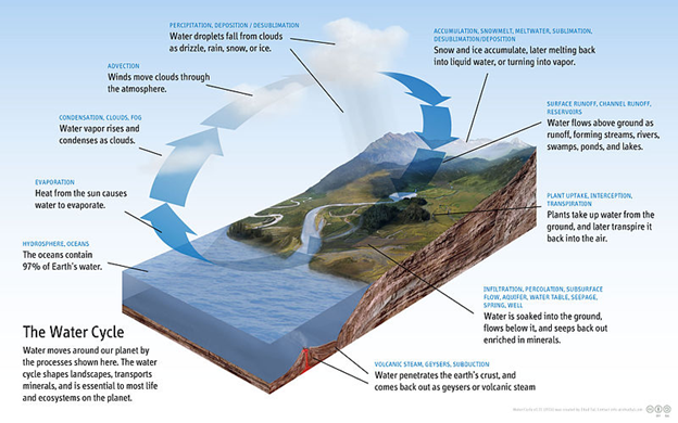
https://commons.wikimedia.org/wiki/File:Diagram_of_the_Water_Cycle.jpg The characteristics of the water cycle requires us to consider the basin or watershed of the Congo from an integrated perspective (integrating viewpoints of various stakeholders from different parts of the basin).
Forests impact water both terrestrially (surface and groundwater availability) and in the atmosphere (water vapor and rainfall). Water is absorbed by trees in forests, and is evaporated as water vapor into the atmosphere through evapotranspiration, or it runs-off into streams and rivers. Deforestation decreases evapotranspiration from the land surface and increases run-off, with impacts to river discharges and sedimentation and erosion processes. For example, 2/3 of the discharge increases in a watershed in Brazil over a 20-year period were estimated to have resulted from deforestation in the area. Almost paradoxically, even afforestation can reduce surface water flows downstream as forest vegetation also needs water to grow. One study estimated that afforestation on grasslands and shrublands reduced annual runoff by 44% and 31% respectively.
Understanding and addressing the forest-climate-water nexus is particularly relevant in the Congo Basin given deforestation trends and the growing threats to the forest. Evapotranspiration in the Congo Basin is high; one study estimated ET at 75% to 85% of annual precipitation in the Congo Basin, an estimate that was similar to a later study that found ET peaked in the Congo Basin at roughly 1,500 mm/year, which decreased to the north and south to less than 1,000 mm/year. Research suggests that deforestation in the Congo Basin may increase surface warming by roughly 0.7°C, which is nearly half of all GHG-induced warming in the region. Potential impacts of climate change on runoff in the Congo Basin vary temporally and spatially. Climate change may increase runoff in the Congo Basin by 7% on average by 2065, with runoff increases projected in the equatorial region and the northern and southwestern areas of the Congo Basin, but runoff decreases projected in northeast and southeast areas.
Using a regional climate model, one study estimated that the loss of the Congo Basin rainforest may decrease rainfall by 42% over the western Congo while increasing rainfall by 10% in the eastern part. Further, increased albedo due to deforestation resulted in a cooler and drier climate over the basin as a whole. Another study simulating land-surface processed in the Congo Basin found decreases in precipitation and evapotranspiration when forests are converted to grasslands, and an overall reduction in the hydrologic cycle indicative of drought.
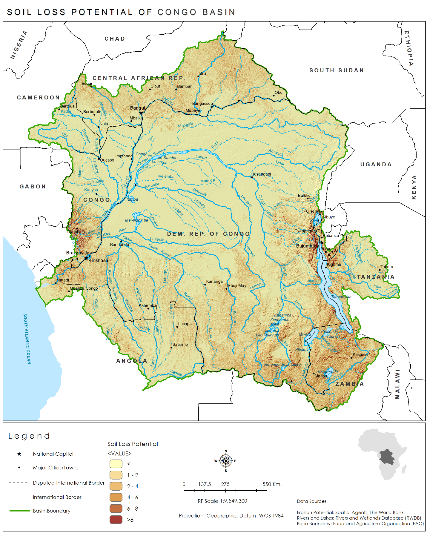
The rainfall-runoff processes in the basin can also impact erosion and siltation in the basin. Some of the erosion-prone areas are shown in this map.
Understanding the Nexus: Africa-wide
Precipitation-Sheds: Traditionally, a basin or watershed context was considered sufficient as a system to internalize hydrologic externalities. However, recent work is shedding light on the concept of “precipitation-sheds”. The concept of precipitation recycling, or the amount of precipitation falling within a region that is attributable to evaporation within that same region, incorporates the atmospheric component of the hydrologic cycle into hydrologic assessment. A precipitationshed, coined in a recent study, is “the upwind atmosphere and upwind terrestrial land surface that contributes evaporation to a specific location’s precipitation, e.g. rainfall”. This is an important concept to better understand the regional hydrologic connectivity of the Congo Basin from two points of view – Where does the rainfall in the Congo basin come from? and Where does the evapotranspiration from the Congo basin go to?
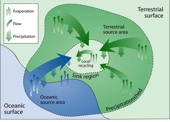
A global perspective of precipitation-sheds indicates where precipitation is locally recycled through terrestrial evaporation using a concept of moisture recycling within a sink region, and where precipitation is sourced from oceanic and terrestrial source areas external to the sink region. For example, about 40% of global precipitation on land originates from land evaporation with the remainder from the sea. About 57% of all terrestrial evaporation globally returns as precipitation on land. Precipitation recycling has been found to account for 30% of rainfall in the Amazon and up to 50% in Africa (drainage basin of the Niger River).
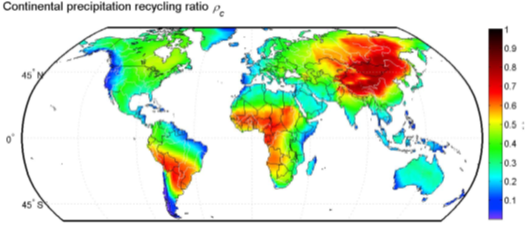
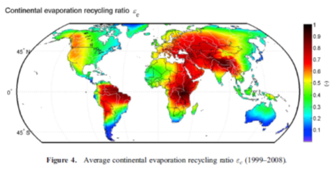
The first figure shows sinks for continentally evaporated moisture and represent higher areas of terrestrial precipitation recycling, where more of the precipitation that falls comes from terrestrial sources; The second figure shows source regions for continental precipitation and represent higher areas of evaporation recycling, which are locations in which evaporated moisture will fall as precipitation over continents.
Inter-Tropical Convergence Zone (ITCZ): Another key concept to understand in the regional context of the Congo Basin is the ITCZ (also known as the doldrums for its calm, monotonous, windless weather) where the northeast and southwest trade winds converge. The ITCZ moves seasonally very predictably - except in El Nino events where it is deflected toward unusually warm sea surface temperatures in the tropical Pacific - and over long timeframes, dramatically impacting precipitation in Africa. Importantly, the ITCZ is seen by some researchers as delivering precipitation to the Ethiopian Highlands; though some research has suggested that the ITCZ is independent of the moisture system that produces most rainfall, and only impacts the southern Sahara and northern Sahel.
Explore the monthly Africa ITCZ movement:
The
main source of
rainfall in the Congo basin
is moisture evaporated over East Africa
(especially the Great Lakes region). In turn, the Congo basin is understood to be a major source
of moisture for precipitation in the Sahel. One study found that
the
Indian Ocean along with
evaporation from the Congo Basin were the primary moisture sources of rain falling in the
Congo
Basin: in rainy seasons the southwestern Indian Ocean contributed about 21% of the
moisture and
local recycling from the basin itself contributed 25%. These understandings are evolving as more
complex modeling of the global moisture cycling proceeds.
Evidence suggests that the Congo basin, in turn, is the source of precipitation for a number of other sink regions. For example, the Congo basin has been shown to deliver moisture to the Ethiopian Highlands, which in turn are responsible for 85% of the surface water reaching Aswan, Egypt through the Nile River basin. One study found that air crossing over West African rainforests during the summer rainy season transports with it 38% of moisture that reaches the Highlands.
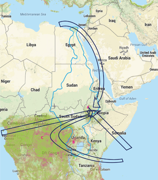
The Nile River Basin (outlined in blue), and four major routes for atmospheric moisture transport to the Ethiopian Highlands (“A” in red). West African rainforest (“C” in red and the whole greenish area); the reddish‐purple in “C” indicates the progressive deforestation. “B” in red indicates the Equatorial Lakes Region, the source of the White Nile. Source: (https://onlinelibrary.wiley.com/doi/full/10.1002/wat2.1317)
Studies have also noted the impact that deforestation in the Congo Basin may have on the monsoon season in Africa. Deforestation on the coast is thought to impact monsoon circulation negatively and consequently to contribute to drought in West Africa.
In addition to deforestation, land degradation has also been shown to impact precipitation and drought in North Africa. One study found significant decreases in precipitation over degraded areas from land degradation in the Sahel and West Africa, with decreases in precipitation from land changes in the Sahel occurring to the distant south of the degraded areas.
Some of the implications for this are significant in terms of the systems we might consider for different types of regional collaboration. The evidence suggests that deforestation within Congo Basin countries is not an issue for just countries within the Basin to deal with because deforestation may potentially impact many other distant countries in a very fundamental manner, calling for even more regional and global approaches to do justice to the complex interconnections generated by precipitation-sheds. For example, researchers indicate that the Congo and Nile basins and some other associated catchments function as a single atmospheric moisture/rainfall system, and therefore deserve to be studied as such to capture the interconnections rather than in a fragmented manner. One study discussed degrees of “moisture independence” and noted that countries that are large and isolated have the greatest independence. Importantly, nations that are “water poor” in terms of the amount of water they need to import from other countries tend to be economically poorer as well.
The Forest-Climate-Water nexus does not only have ramifications in the Congo basin or the Africa region, but is of global concern. Impacts of precipitation-sheds in the Congo Basin and African continent are evident in other areas of the world. For example, evaporation from the Eurasian continent has been shown to account for 80% of China’s water resource base, and evaporation from the Amazon rainforest to deliver 70% of the water resources in the Rio de la Plata in South America.
The Congo basin has tremendous biodiversity benefits – being home to about 10,000 species of tropical plants (30% endemic) and a range of endangered charismatic macrofauna – including mountain gorillas, elephants, chimpanzees, and bonobos, and many other species (400 species of mammals, 1000 species of birds, and 700 species of fish (source: WWF).
The Congo basin countries will experience impacts from climate change despite contributing little to greenhouse gas emissions globally. However, the little that they do contribute in the countries of the Congo basin tend to be related to land use change and associated agriculture.
Forests impact climate both through impacts on the carbon cycle and by impacting the cycle of energy and water from terrestrial areas into the atmosphere. Forests act as carbon sinks, continually sequestering carbon from the atmosphere until cut or burned. Research suggests that forest loss leads to an increase in warming, increasing both mean and maximum temperatures, with specific impacts dependent on climatic zone. Other research suggests that climate impacts depend on where deforestation occurs, and at a global-scale deforestation has a cooling effect on the global climate. Another study concludes that overall impacts of deforestation vary with latitude: in temperate and boreal zones in the Northern Hemisphere deforestation results in cooling due to a strong albedo effect, while deforestation results in warming in the tropics, where evapotranspiration efficiency and surface roughness are the stronger factors.
Deforestation may lead to surface warming due to reduced evaporation; reduced evaporation also reduces water vapor in the atmosphere and thereby reduces precipitation. Recent research is underscoring the potential for deforestation to reduce rainfall in the tropics, due to evidence that deforestation reduces evapotranspiration and therefore reduces water recycling. In many tropical areas, air masses that travel over vegetated surfaces generate at least two times the amount of rainfall as air masses moving over deforested lands. Research also suggests that deforestation in the tropics may result in a warmer and drier overall climate. One study modeled impacts of deforestation and found it caused warming up to 0.28K/decade on average temperature in tropical regions, a cooling up to –0.55K/decade in boreal regions, weak impacts in northern regions, and strong warming (up to 0.32K/decade) in southern temperate regions, with afforestation having opposite impacts.
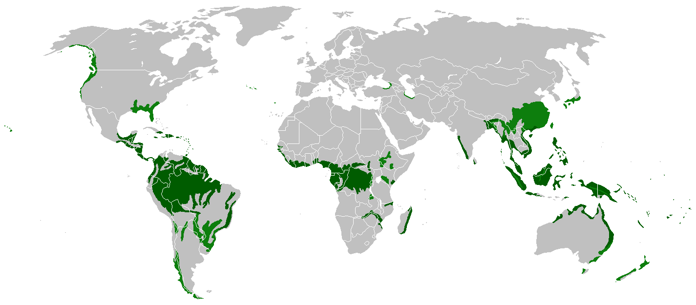
Rainforest Areas Globally
Source: Wikimedia commons, https://commons.wikimedia.org/wiki/File:Rain_forest_location_map.png.
The Amazon Basin, Congo River Basin, and Southeast Asia are home to the three primary tropical forest areas in the world. Due to the ecosystem services these forests provide, they are global hotspots for biodiversity, climate mitigation, and, as the research in this e-book suggests, water provision. Independently and together, these tropical forest areas hold tremendous opportunities for climate regulation, carbon sequestration, and a host of other social, environmental, and economic co-benefits if they can be adequately preserved both in terms of quantity and quality. Challenges to these tropical forest areas, however, are immense, and will require the same degree of holistic, interdisciplinary research across sectors and multiple stakeholder engagement in order to capture and maintain their potential and actual ecosystem service provision.
Deforestation is a critical threat to the health and functioning of the Amazon rainforest. Driven primarily by clearing for cattle ranching, deforestation in the Amazon Basin is concentrated in Brazil and has increased in the recent past: since 1978 the Amazon rainforest has lost over 750,000 km2. This is alarming given that evidence suggests that deforestation and land cover change in the Amazon may reduce precipitation and amplify droughts in the basin, which have increased in the recent past (two once-in-100-year droughts in 2005 and 2010). In fact, the Amazon basin may be moving to a drier steady-state ecosystem. One study estimates that reductions in moisture recycling from Amazonian deforestation may reduce wet-season and dry-season precipitation by 12% and 21%, respectively, by 2050.
The Indonesian rainforest is also under threat of continuing deforestation. Driven by agricultural conversion, logging, and a host of other threats, deforestation rates in Indonesia are among the highest in the world. Notably, deforestation is having impacts to Jakarta, where reduced water regulation in previously forested areas contributes to flooding. Forest fires in Indonesia also have regional implications.
Impacts of changes to these tropical forest areas extend to the global scale. A study on global hydroclimatological teleconnections found a number of distant impacts of tropical deforestation, including deforestation in the Amazon and Central Africa reducing rainfall in the lower U.S. Midwest in spring and summer and the upper U.S. Midwest in winter and spring. Deforestation in Southeast Asia, the other major tropical forest region, was found to impact China and the Balkan Peninsula, while deforestation in all three tropical forest regions decreased winter precipitation in California and increased summer precipitation in the Arabian Peninsula. It is important to note, however, that the study discusses the lack of scientific consensus “…on regional impacts of deforestation on precipitation in the Amazon basin or on the response of vegetation to altered rainfall regimes within the region” due in part to the varying models and scales used to assess deforestation impacts on precipitation for the Amazon Basin. This same lack of consensus appears for the Congo Basin appears to stem from modeling efforts at various geographic and temporal scales and levels of resolution.