Water Resources
The Congo basin has a dense network of streams and is home to many lakes in its upper reaches.

Water Supply
The Congo river has the highest flow of any river in Africa and is second only to the Amazon globally. The Congo Basin has an abundance of water since the estimated average annual precipitation volume and discharge are 5,630 cubic KM3 41,000 m3/s or 1260 km3, respectively. At Kinshasa, the average flow ranges from 32,800 in August to 57,000 m3/as shown in the graph below.

The available historical data for the Congo Basin hydrologic stations can be interactively visualized in this map.
There is a decreasing trend of flows in many rivers in the Congo basin (e.g. Ubangi river below that shows a continuous decreasing trend of inter-annual minimum flows).

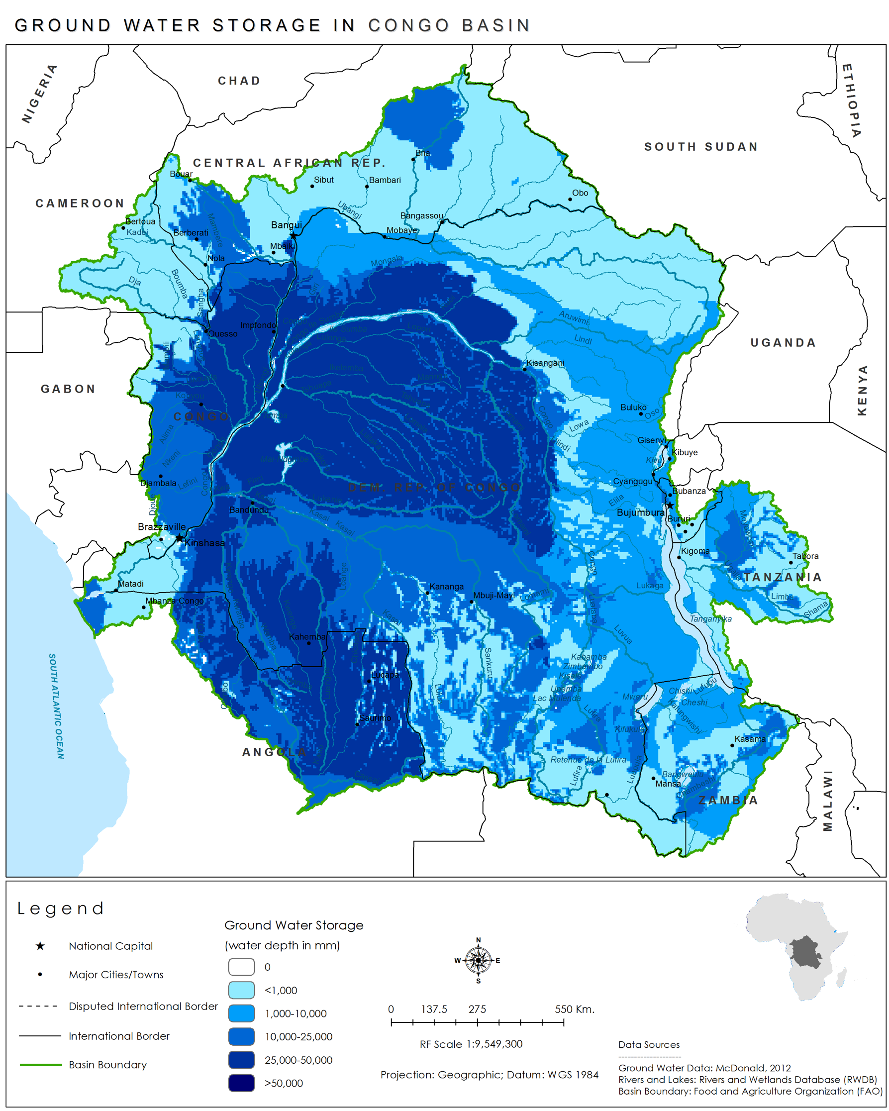
Much of this groundwater is not exploited given the high precipitation and surface water availability, low level of irrigation, and lack of access to energy to pump the groundwater. Currently, there is a lack of useful information on groundwater withdrawals in the basin. The Grace satellites (and its follow-on mission) measures change in water storage by measuring changes in gravity over time impacted by large water changes on earth; however, it cannot identify the difference between surface and groundwater. When clicking on a point on the GRACE map, a plot displays seasonal total water volume over time that allows identification of wet and dry season along with seasonal amplitude.
Demand
Although there is limited water use in the Congo basin compared to its supply, there is increasing water demand for the environment, industries, agriculture and domestic water supply. Due to the high rainfall, Agriculture is predominantly rainfed. The table shown below is the approximate water per capita usage for each sector per country. The natural environment requires the greater demand for water due to the abundance of vegetation. The annual Potential Evapotranspiration is 1,100mm/yr while the actual ET is approximately 75-85% of rainfall. Dry season ET is estimated to be between 800-1200 mm, while wet season ET is approximately the Potential Evapotranspiration.
| Countries | Agriculture (m^3/cap) | Domestic (m^3/cap) | Industrial (m^3/cap) |
| DRC | 1.20 | 7.77 | 2.45 |
| ROC | 1.10 | 17.58 | 6.62 |
| Cameroon | 14.02 | 14.02 | 5.90 |
| Central African Republic | 0.10 | 14.88 | 2.97 |
| Equatorial Guinea | 1.33 | 21.08 | 4.00 |
| Gabon | 28.98 | 60.91 | 10.14 |

Monitoring
The number of discharge stations has significantly decreased over time in the Congo Basin. Before 1960, discharge was measured at 400 locations throughout the basins, but there are only 10 active stations. The Global Runoff Data Centre provides data for 99 stations where none are currently active.
Monitoring of water use is even more limited with little accessible data to estimate consumption or trends. The historic photo displays written records of hydrologic flow data with river stage measurements from a DRC Kinshasa office.

Water Infrastructure
The Congo basin has few large dams for storage. Major dams in the basin that are operated for hydropower and not water storage (although they have ponding storage) include Inga I, Inga II, and Imboulou. Total number of dams in the basin are forty nine, when using the GlObal geOreferenced Database of Dams.
There are some hydropower plants in the region but the entire basin has poor power generation as shown in the interactive map (Source: WRI), with some of the lowest levels of per capita electricity consumption in the world.
There is also increasing interest in enhancing the navigability of many of the rivers in the Congo basin.

Source: UN Joint Logistics Centre in DRC and Michelin maps
Water INstitutions
Within Country: Each of the countries in the Congo basin has a varied patchwork of governance arrangements for forests, climate, and water aspects. There are uniform challenges of capacity and skills (especially in effectively using modern technology) and in working effectively with each other in all these institutions at various administrative levels.
Regional Level: The need of coordination to organize the navigation of international waterways is one of the main reason for the creation of the CICOS. In 1999 four riparian countries (Cameroon, Central African Republic, Republic of the Congo and the Democratic Republic of Congo) signed an agreement to establish a uniform river regime and create the International Commission of the Congo-Ubangi-Sangha Basin (CICOS). Gabon and Angola have joined the CICOS respectively in 2011 and in 2015. CICOS was mandated with the promotion of inland navigation. The CICOS is aimed at assisting its member countries with implementing initiatives for inland shipping and sustainable water management.
The coordination platforms between the six countries and the way they involve the private sector are unique in the region. The CICOS is composed by three main bodies:
- The Committee of Ministers (decision-making body): It defines the development and implementation policy of the watercourses of the Basin. It is composed of Ministers in charge of inland navigation and Ministers in charge of water resources management.
- The Management Committee (consultative body): It is responsible for preparing the deliberations of the Committee of Ministers. It comprises three members per country, two of them from the Ministry in charge of inland navigation, representing respectively the river transport administration and the river operators; the third member represents the Ministry in charge of water resources (an expert).
- The General Secretariat (executing agency): Led by a Secretary General, the General Secretariat is the executive body of CICOS which is in charge of the implementation the Committee of Ministers' requirements according to the missions set by the Member States. It is composed of four directorates, six attached services and several experts in river navigation, transboundary management of water resources and environment.
Since its creation, CICOS has lacked financial and human resources as the contribution of its member states are not enough to execute its main mandates (the promotion of inland navigation and of the integrated management of water resources).
CICOS is relying on the financial support of the bilateral cooperation (AFD and GIZ mainly) to develop activities. Thanks to this support, CICOS has published two strategic documents: the Navigation Strategic Action Plan (PAS) (2016-2020), and the River Basin Management Plan (SDAGE) (2016-2020). The PAS and the SDAGE have identified priority actions - principally to improve knowledge and capacity in the field of navigation and integrated water resource management (IWRM).
The PAS and the SDAGE clearly highlight the current gaps in terms of knowledge and capacity that the CICOS is experiencing in different fields:
- Lack of sectoral data (fisheries, agriculture, drinking water, navigation)
- Lack of Geographical Information System (GIS)
- Lack sectoral statistics (fisheries, tourism, drinking water, sanitation, energy, agriculture)
- Lack of transboundary legally binding instruments (water charter)
- No initial status of the ports and transport boats
- Lack of knowledge on waste discharge
The cost of priority, capacity strengthening actions proposed within the PAS and the SDAGE, and necessary for CICOS to implement efficiently its mandate of the promotion of the navigation and the development of IWRM, has been evaluated at more than 40 million USD, A part of these actions will be financed by bilateral donors. The current project proposes to finance another part of these key actions that would not be financed by other donors (for about 15 million USD) in the framework of technical assistance provided to the CICOS.
The Congo basin countries are also part of many Regional Economic Communities (RECs) in Africa as illustrated in this infographic.
